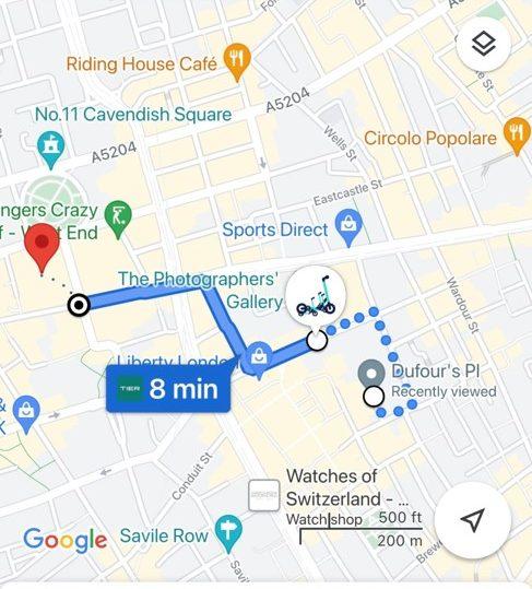
Today, micro-mobility leader TIER has teamed up with Google Maps in the UK, giving people in London and York access to the company’s e-scooters through the popular navigation app.
The integration will enable riders plotting a route via Google Maps to easily locate nearby TIER e-scooters, as well as clearly displaying how much their journey will cost and how long it will likely take. Google Maps users will also be told the walking distance to their closest scooter and the current battery power of the vehicle.
TIER, Europe’s largest e-scooter operator, launched in London in June 2021 and currently has e-scooters in nine boroughs across the capital. The company is also approaching the one-year anniversary of the launch of its e-scooter scheme in York, and it currently has 750 e-scooters and e-bikes in operation in the city.
More from News
- UK Drivers Could Be Paying A Lot More For Fuel This Year, Here’s Why
- Beyond Wearables, What SportsTech Developments Are Worth Keeping An Eye On?
- New Research Finds 8 In 10 Buyers In The UK And EU Now Use AI Payments
- Silicon Valley’s Hottest Coding Startup Got Caught Building On Chinese AI – And Founders Should Be Asking Why It Matters
- Will We See More Energy Efficient AI Systems In Our Lifetime?
- Will The US Lifting Sanctions And Easing Tariffs Actually Stabilise Oil Prices?
- UK Unemployment Holds At 5.2%, But Can We Trust ONS’ Jobs Data?
- What Will The EU Inc. Proposal Mean For The Fintech Industry? Experts Discuss
The announcement today means that TIER’s integration with Google Maps is available in 52 European cities and is the latest in a series of innovative collaborations that strengthens their e-scooter service in the UK. This includes TIER’s partnership with ride-hailing app FREE NOW, to discourage ‘drink riding’ and the company’s pioneering Safety Pricing model which ensures riders are not charged when stationary during trips.
Fred Jones, Vice President and Regional General Manager for TIER across Northern Europe, said: “By collaborating with one of the leading navigation apps, we are expanding access to TIER to more riders, providing them with better, greener options to navigate the city.
“TIER’s mission, to get people out of private cars and change mobility for good, is better achieved through these collaborative partnerships. Our integration with Google Maps doesn’t just encourage people to take a new green form of transport but also a transport that is more convenient and cost-effective.